
TIME VISITED: December 2015 and February 2016 BUSY ? MODERATELY
WEATHER: All four seasons in one day LENGTH: 19.4 KM DAY HIKE
WHERE TO STAY: AIRBNB IN TAUPO EXPENSIVE?: $
Wooooo this is up there for one of my favorite places in the world, I loved this hike so much that I did it three times while I was in New Zealand! Tongariro National Park has 3 active volcanoes: Tongariro, Ngauruhoe (Mount Doom in “The Lord of the Rings” films) and Ruapehu- home to some awesome ski slopes. The Tongariro Alpine Crossing trail passes through the Emerald Lakes and boiling mud pools and peaks at the still-active Red Crater. You probably read that and thought this is a joke, this sounds like a made up place. Well I can tell you from experience it is indeed a real place, but the whole time you will be questioning if you are dreaming. This park could keep you busy for days, even a week, but I love to do the one day hike- super challenging and the views seem too good to be true!
After being in New Zealand for a month I had the chance to stay with a friends mother-in-law in Taupo. At this time in my travels I was hitch-hiking everywhere, but she didn’t feel comfortable with me doing that. Since she was allowing me to stay at her place I thought ok, I will respect that and agreed to go with a tour company. Not only did I see some incredible views on this hike, I also met some of my very close friends on the tour bus so I am so happy I decided to take one !
WHERE TO BOOK AND WITH WHAT TOUR COMPANY
New Zealand is extremely tourist friendly and most towns and cities have an iSITE where you can get loads of tourist information! You can look up information about the one in Taupo and what they offer HERE. They are extremely helpful and will book your tours or give you advice on where to visit during your stay.
There are many tour companies that will take you up to Tongariro National Park, but this particular iSITE used Tongariro Expeditions and I couldn’t recommend them more. The tour was about $60 US Dollars and they simply provide transportation to and from the park. When I booked, they had specific days I could and could not go because of the weather up in the park that week. The weather changes drastically on this hike so tour companies will only take you if there isn’t a lot of rain, I got lucky and they were going out the next morning before a week of rain was coming in!
PACKING FOR THIS HIKE
Absolutely wear hiking boots, I made the mistake of doing it with Nikes and I think it was fine for most of the hike(you’ll read more about that below) but if it would have started raining I would have been miserable. They say you can witness four seasons on this one day hike and I did all three times! There were times where I was walking in a sports bra and other times I was freezing my ass off wearing a winter jacket. Here is a detailed packing list for this hike, whatever you do, don’t forget to bring at least 2 liters of water.
GETTING TO THE PARK
This company is extremely accommodating and will pick up at most Taupo hotels or hostels in town, they will pick you up in a bus that looks like this.

They will pick you up in Taupo and the drive is about an hour to the starting point at Mangatepopo Car park. On our way to the park we drove all the way around Lake Taupo and although it was drizzling it was still beautiful. About half way to the park our driver yelled back , “You kids might get lucky looks like it might clear up!” And it did, by the time we arrived the clouds had cleared and she came over the intercom and said “You kids don’t know how damn lucky you are, the clouds are opening up and no one came up here because they thought it might keep raining so you are going to have the whole park to yourselves!” I couldn’t believe it, it was sunny the entire time and for the first hour I didn’t see another group of people.
IS THIS HIKE HARD? HOW LONG WILL IT TAKE?
The hike is 19.4 Kilometers (roughly 11 miles), the hike shifts from easy to difficult multiple times and this is one of the many reasons why it is one of my favorite hikes. You can really push yourself and then have time some to relax as well. They say to give yourself 5-8 hours for this hike and if you want to hike up Mount Tongariro or Mt Ngauruhoe (Mount Doom in “The Lord of the Rings” films) give yourself an extra 2-3 hours. This hike took me 5 1/2 hours the first time, but I didn’t add Mount Doom or Tongariro.
I am going to give you a short recap of each section of the hike and just so you are aware, there are signs pointing you in the right direction throughout the entire hike so don’t worry about getting lost!
TONGARIRO ALPINE CROSSING
Mangatepopo car park to Soda Springs
The beginning of this hike reminded me of something out of the movie Sound of Music. Wide open spaces, tall grass, wild flowers and a beautiful stream-running through a vast valley-right next you. The first hour was very easy in my opinion, it literally felt like a stroll, trails were well groomed, smooth and there was hardly any elevation change.


![]() When you turn around you can see the peak of Mount Ruapehu off in the distance. (it has to be a clear day)
When you turn around you can see the peak of Mount Ruapehu off in the distance. (it has to be a clear day)

They said you will walk for about an hour and a half before you reach Soda Springs, depending on your speed you can give or take a half hour, it took me about 50 minutes but I was walking pretty fast. The first time I did this hike I walked the extra 15 minutes to get closer to the small waterfall and Soda Springs, but the next two times I skipped it. Of course it was beautiful and peaceful but there are much more beautiful things to come in the next few hours so personally I think you could skip it! Skip the falls but don’t skip the toilets, they are the last ones for 4 hours, it still blows my mind that they don’t have one in between!


Soda Springs to South Crater
This is where it starts to get very difficult, right after Soda Springs you will come to this sign.

It basically says, “Yes the past hour was pretty easy but that is all about to change.” This section of the track, known as the Devil’s Staircase, is steep – climbing from 1400 to 1600 meters above sea level. Definitely take your time on this section, I consider myself in pretty good shape and this part still kicked my ass. Give yourself about an hour, I was an idiot the first time and tried to push through (did it in 30 minutes, not giving myself enough breaks) and I REALLY felt it the next two days. This part may be difficult but the view down to the valley and out across the surrounding countryside was so worth it!


South Crater to Red Crater
Then you come to an area and feel like you are on mars, it starts off really easy and on a hot day it will get very warm, this is where I got really hot and stripped down to my sports bra. It was about 80 degrees with absolutely no breeze for about a half hour. Then it gets very difficult again, I actually thought this part was worse than the Devil’s Staircase because the weather changed so quickly, I went from sports bra to freezing with my coat, hat and gloves on- but once again, worth it.


This is what happens when it is so sunny you can’t see your camera and you think you are taking a picture of Mt Doom but instead this is what you get…..

Once you reach the peak and where Red Crater is, it is great place to rest and enjoy lunch. Now this all depends on the weather, the first time I did this hike the wind stopped at the top and it was perfect, the second and third time I came it was too windy to enjoy lunch there. After lunch walk over to see closer views of the Red Crater, or from here you also have the option to add on to your hike and head up to Tongariro Summit, this will add about an hour to your hike. The views from here are amazing but it is very windy and much colder at the top so be prepared, my first time I decided to skip the summit and head to see the Red Crater and venture down to Emerald Lakes.

These next two pictures of the Red Crater are from two different days.


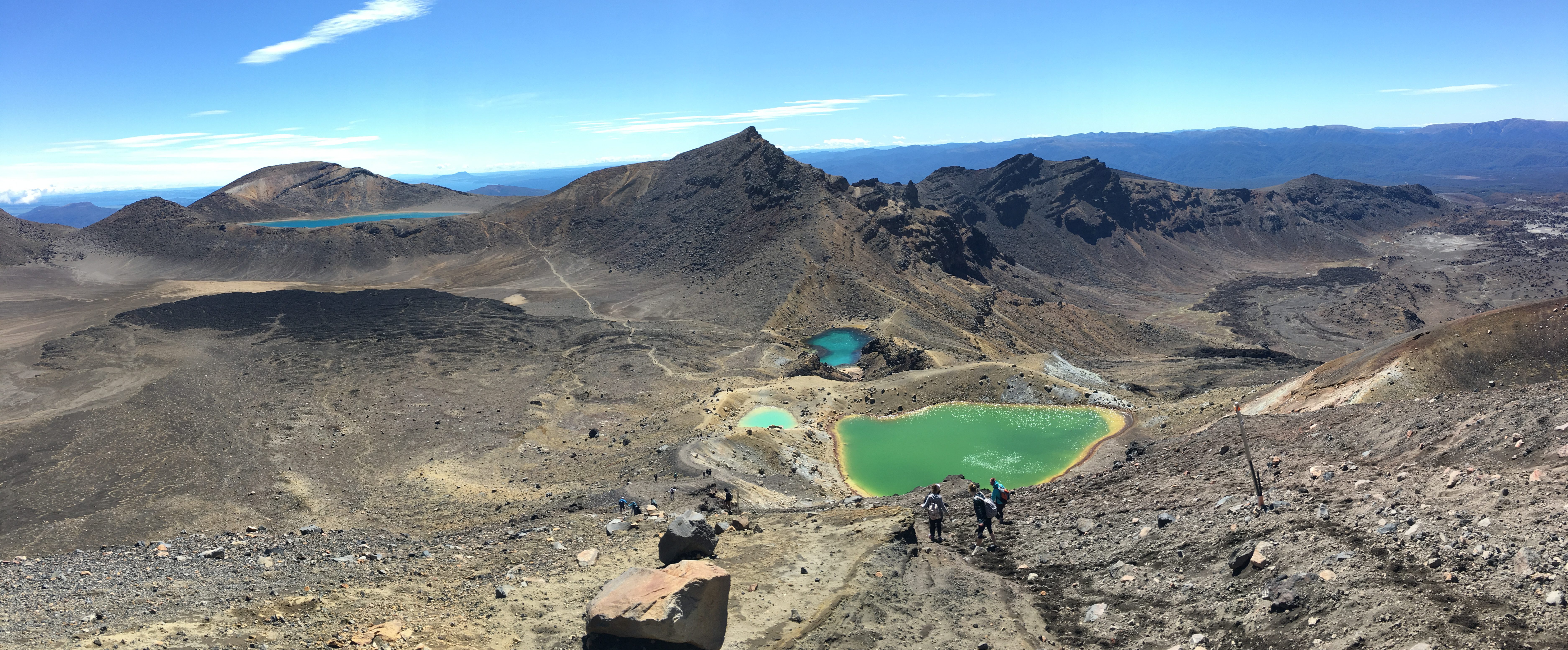
Red Crater to Emerald Lakes and Blue Lake
After checking out Red Crater you will have a pretty steep hill with a lot of loose gravel to walk up.

You get to the top of this hill and are welcomed with this view, immediately I thought “OMG Emerald Lakes(what I was most excited for)!” Nope, this is just Blue Lake off in the distance.


This is where I really regretted not having hiking boots. ROOKIE MISTAKE. The walk up the hill wasn’t bad, but I fell twice walking down to Emerald Lakes. You can see how steep it is because the people in this picture are walking down sideways!

This is where the hike is the most beautiful(in my opinion)! It is easy to get distracted by these lakes but please take caution heading down this extremely steep hill!


Here are some close ups of these beautiful lakes!

If you see pictures of these lakes on different sites and think, “Huh that isn’t as bright as some other pictures.” Yes, a lot of people highly edit their pictures these days, but this lakes change with the sun. Here is a picture of the same lake 30 seconds later just because a little cloud went over the sun.

I loved the two small ones, they had such a unique and vibrant colors!


Red Crater to Blue Lake
This is a pretty easy part of the hike, you will walk about 30 minutes to get closer to Blue Lake.

Blue Lake to Ketetahi Hut–Ketetahi Car Park
To be honest the rest of this hike was quite a blur, it is kind of hard to explain but maybe you will understand from the prior descriptions. This hike takes it out of you! It is both physically and emotionally draining-with the drastic weather changes and physical demands of the steep summits, my body didn’t really know what to do. I am also an emotional person so I cried pretty damn hard at some of the views because I just couldn’t believe I was there, witnessing something so beautiful. So those last 2-3 hours(depending on pace) down to the end point were crazy for me! I would get this crazy adrenaline and start running some of the way and then I would stop and see views like this and just sit down for a minute.


Because it was pretty warm outside, I was chugging water, so I was pleased when and hour and a half after the Blue Lake I arrived at the Ketetahi Hut and there was a toilet! After that you have about 1-2 hours(depending on pace) down to the Ketetahi Car Park where Tongariro Expeditions will pick you up again!
So just a recap: it took me about 5 ½ hours to do this hike but the tour companies give you about 8 hours to do it so take your time! I was an idiot and ran some of it the first time I hiked it, but definitely took more breaks the next two times I hiked here.
If you are looking for more of a detailed overview check out the MAP page on Tongariro Expeditions website. There is also a great description on the parks website HERE.
I hope you enjoy this hike as much as I did, here is a picture of me enjoying these beautiful lakes for the third time!

Would you do this hike!? Have you done it? What did you think!? Read more about my New Zealand posts HERE!